
Hailey's Land Use Map
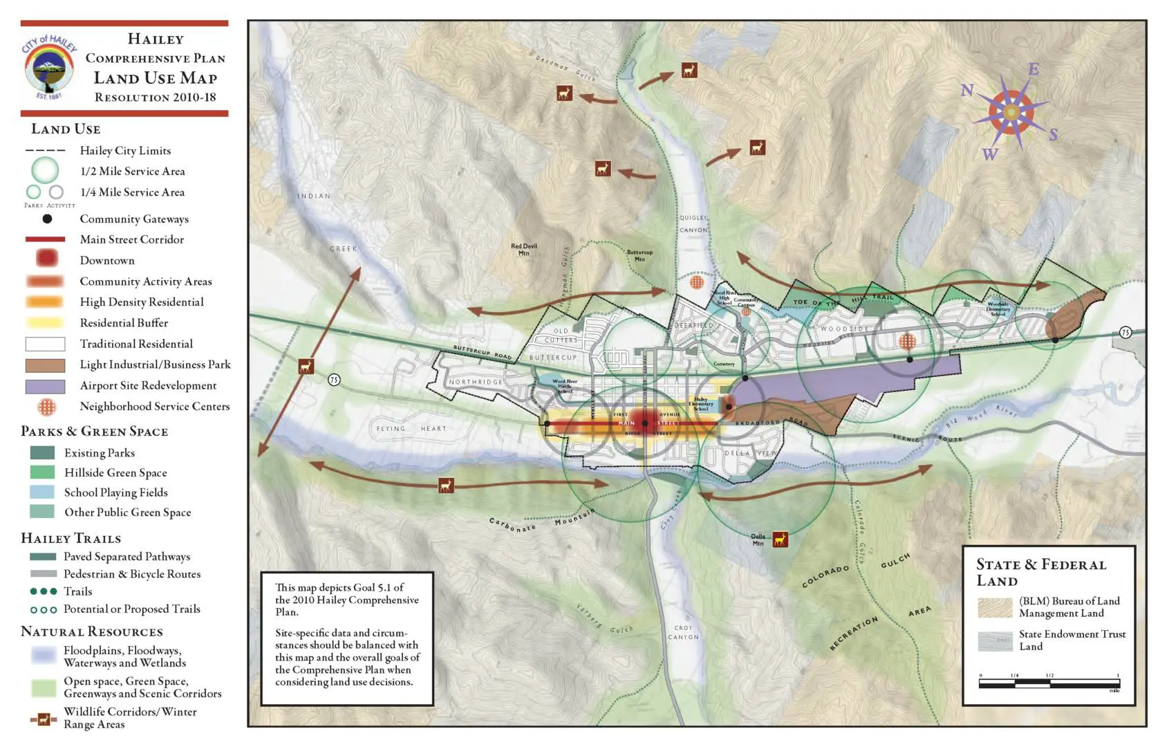
Hailey's official Land Use Map establishes a basis and direction for the expansion
and/or location of business, residential, industrial, institutional and green space areas within and adjacent to the City.
A Land Use Map is a required element of the Land Use component of the Comprehensive Plan. Pursuant to Idaho Code requirements, the Land Use Map reflects suitable projected land uses for the City. The creation of a land use map establishes general direction for projected land uses within and adjacent to the city. The Land Use Map depicts broad community goals.
When considering land use applications, site-specific data and circumstances should be balanced with the overall goals depicted on the map. The following land use related goals, and the associated Land Use Map, are intended to establish principles to help guide future development. The goals are not intended to be prescriptive. It is important to recognize that there are often tradeoffs that have to be evaluated in land use decisions. It is also important to acknowledge that to encourage development of a certain type in specific areas will likely require thoughtful and creative incentives.
As described below, land-use planning and zoning decisions are guided by the stipulations of Zoning Districts and public processes laid out in Hailey's Municipal Code. Each week, City staff and its governing bodies process the community's initiatives to develop within the City's vision or to amend it.

Hailey's Zoning Districts
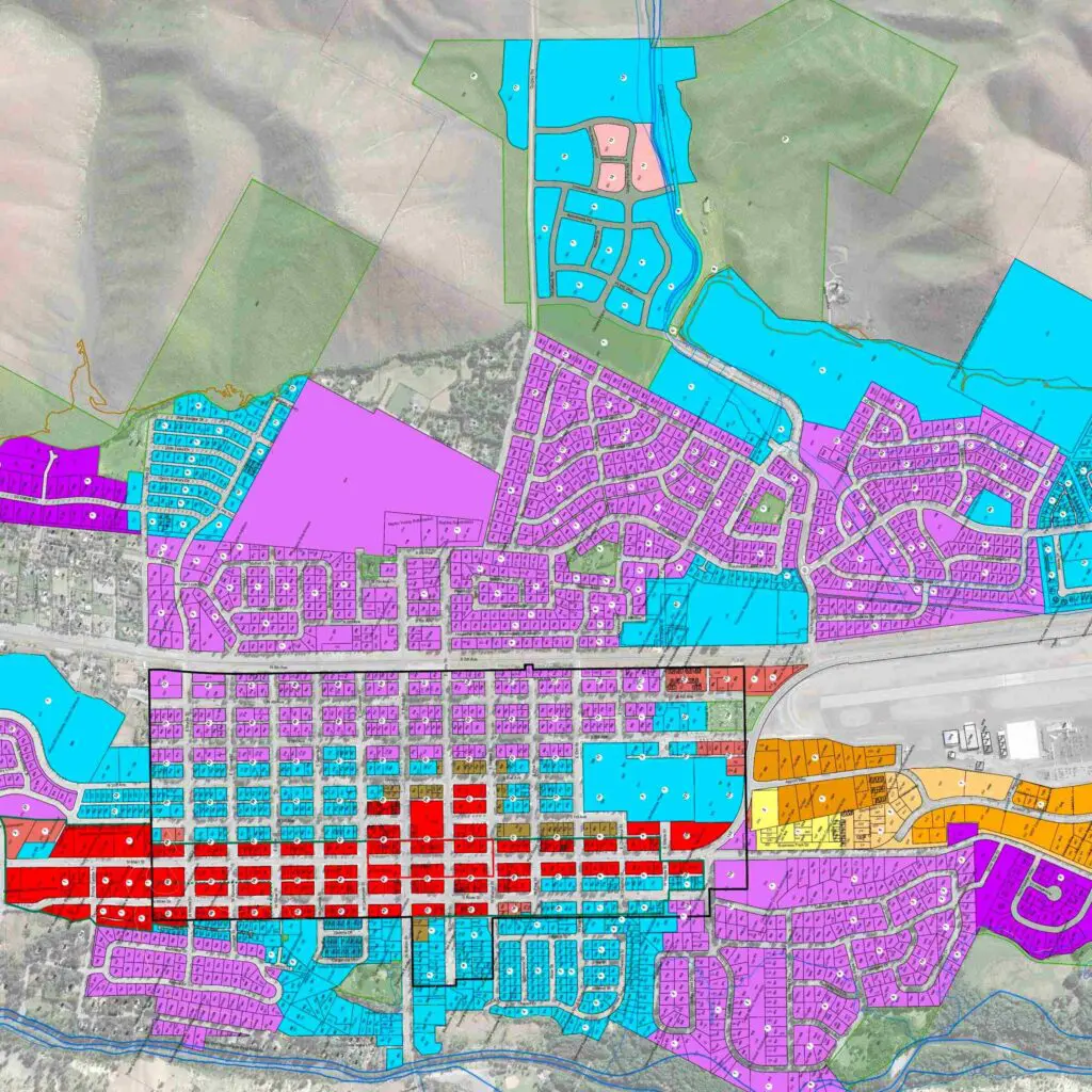
Land use goals may be achieved, in part, through effective zoning. The Municipal Code governing Zoning Districts regulates land uses, for example determining what types of commercial, residential, industrial uses are desired in different areas of Hailey. Hailey's Land Use and Zoning Maps, as well as ongoing efforts and decisions regarding developments and amendments to the Municipal Code, are determined through iterative democratic processes. Such process include Public Hearings of community driven applications at public City Council and Planning and Zoning Commission meetings, with elected and appointed officials.
The airport district is intended to provide an area that would allow regularly scheduled commercial passenger aircraft services to be used by the general public. The airport district is also intended to allow other general aviation services for private aircraft and private aircraft charter only in conjunction with regularly scheduled commercial passenger aircraft services.
The purpose of the B district is to provide areas for general business and commercial activities and a limited number of residential uses.
The purpose of the CC district is to recognize the built character of the central established downtown area of Hailey, encourage economic development, conserve building resources and enhance the district with increased pedestrian orientation, by modifying the parking requirements for all uses to better respond to the unique conditions and circumstances of the district, all in accordance with the comprehensive plan, for the desirable future development of the city of Hailey.
Learn more about the Central Core Overlay (CC) Zoning District.
The purpose of the Downtown Residential Overlay District (DRO) is to promote the health, safety and welfare of current and future residents of the City of Hailey; to modify the density, bulk and parking requirements of certain areas of the Business, Limited Business and General Residential Zoning Districts in order to encourage the development of mid-density residential housing to help meet the housing needs of the community; to encourage infill while retaining neighborhood character; to create sufficient flexibility to allow for desirable development; to conserve building resources; and to enhance neighborhoods with increased pedestrian orientation, all in accordance with the City of Hailey Comprehensive Plan, for the desirable future development of the City of Hailey.
Learn more about the Downtown Residential Overlay (DRO) Zoning District.
Learn more about the Flood Hazard Overlay (FH) Zoning District.
The purpose of the GR district is to provide areas for a variety of residential uses, and a limited number of other uses compatible with this type of residential development. The intent is to preserve the favorable amenities associated with a residential neighborhood.
Learn more about the General Residential (GR) Zoning District.
The purpose of the LI district is to provide areas for light industrial operations and limited related (or associated) retail sales. "Limited related retail sales" is defined as restricted to retail sales clearly associated with and secondary to the permitted use and of the type not normally located in downtown business districts (e.g., the retail sale of auto parts by an auto dealership). The area is characterized by industrial and service type traffic usage and patterns, and light manufacturing or construction related services. The intent is to group these uses that demand similar circulation patterns and service requirements together and provide regulations to preserve the integrity of the industrial uses while ensuring the health, welfare and safety of the community.
The purpose of the LB district is to provide areas for a wide range of residential uses, restricted business uses and medical facilities. The LB district is intended to allow for commercial uses that would not detract from the established downtown retail businesses, hence general retail is not allowed.
The purpose of the NB district is to provide areas for neighborhood service centers, increase convenience to neighborhood residents and promote other forms of multi-modal transportation and circulation. The uses in the NB district shall be limited commercial uses that will be clearly subordinate to, and support the residential nature of, the area.
Learn more about the Neighborhood Business (NB) Zoning District.
The purpose of the Peri-Urban Agricultural Overlay District (PA) is to recognize changes in community development needs and trends with emphasis on proactive integration of peri-urban agricultural (or village) facilities, educational institutions, semi-public and non-profit projects and recreational improvements to maximize community assets sustainably. Limited commercial uses clearly subordinate to, and supportive of the uses identified above, are also allowed as permitted or conditional uses. The new zone promotes consideration of sustainable principles in all aspects of the community whereby core infrastructure impacts are minimized while maximizing community asset use. (Ord. 1220, 2017)
Learn more about the Peri-Urban Agricultural Overlay (PA) Zoning District.
The purpose of the recreational green belt district shall be to provide areas for public recreation and/or to create and preserve open and/or green space areas for aesthetic and public use. All uses within the RGB district shall be compatible with the protection of natural and scenic resources for the benefit of present and future generations.
Learn more about the Recreational Green Belt (RGB) Zoning District.
The purpose of the Small Residential Overlay District (SRO) is to promote the health, safety and welfare of current and future residents of the City of Hailey; to modify the density, bulk and parking requirements of certain areas of the Business Zoning District (B) in order to encourage the development of higher density residential housing to help meet the housing needs of the community; to encourage infill while retaining neighborhood character; to create sufficient flexibility to allow for desirable development; to conserve building resources; and to enhance neighborhoods with increased pedestrian orientation, all in accordance with the City of Hailey Comprehensive Plan, for the desirable future development of the City of Hailey.
Learn more about the Small Residential Overlay (DRO) Zoning District.
The purpose of the SCI district is to provide an area for master planned business park developments that do not conflict with, and do support, the central business district. The SCI district is further divided into two (2) subdistricts to provide and allow for flexibility within the master planned business park, to group compatible uses, and to better respond to the surroundings of the planned business park. The SCI district is intended to be a category of land use for large parcels and may not be appropriate for smaller parcels.
The purpose of the TI district is to provide a permanent, year round employment base, including research and development, technological industries, uses related to the building, maintenance and construction professions, and limited light industry.
Learn more about the Technological Industry (TI) Zoning District here!
he purpose of the townsite overlay district is to promote the health, safety and welfare of current and future residents of the city of Hailey; to modify the bulk requirements of certain zoning districts in order to better respond to the unique conditions and circumstances of the original Hailey townsite; to encourage infill while retaining neighborhood character; to increase the compatibility and lessen the degree of nonconformity of existing structures; to create sufficient flexibility to allow for desirable development; to conserve building resources; and to enhance neighborhoods with increased pedestrian orientation, all in accordance with the city of Hailey comprehensive plan, for the desirable future development of the city of Hailey.
Learn more about the Townsite Overlay (TO) Zoning District here!
The purpose of the TN district is to provide a buffer zone between residential and business areas within the townsite overly district. The zone provides for restricted business activities within residential areas which are directly adjacent to or across a street or alley from established business zones. Uses shall be limited to those that generate relatively little traffic. The residential character of the area shall be maintained by preserving the existing buildings and requiring new building designs in keeping with the residential nature of the area, and requiring adequate on site parking. The term "transitional" does not imply that the properties within the district will be transitioning from residential to business zoning.
Staff
Community Development Department
Robyn Davis
Community Development Director
(208) 788-9815 x2015
robyn.davis@haileycityhall.org
Ashley Dyer
City Planner
(208) 788-9815 x2019
ashley.dyer@haileycityhall.org
Reese Hodges
City Planner/Resilience Planner
(208) 788-9815 x2017
reese.hodges@haileycityhall.org
Yadira Ward
Community Development Assistant
(208) 788-9815 x2027
yadira.ward@haileycityhall.org